
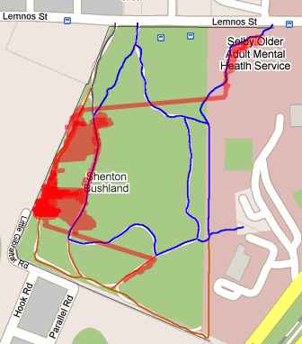
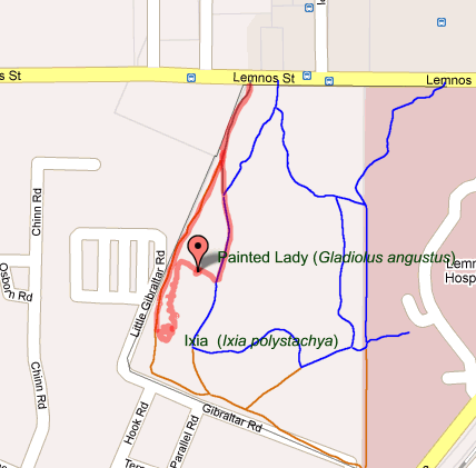
 | Click here to view live map Click here to download the GPX data for this map. Note, this data is an XML file - change the name to .GPX to upload to your GPS. |
 | View live map Click here to download the GPX data for this map. Note, this data is an XML file - change the name to .GPX to upload to your GPS. |
 | View live map Click here to download the GPX data for this map. Note, this data is an XML file - change the name to .GPX to upload to your GPS. |
 | View live map Click here to download the GPX data for this map. Note, this data is an XML file - change the name to .GPX to upload to your GPS. |


 | View live map Click here to download the GPX data for this map. Note, this data is an XML file - change the name to .GPX to upload to your GPS. |
 | Click here to view live map Click here to download the GPX data for this map. Note, this data is an XML file - change the name to .GPX to upload to your GPS. |
 | View live map Click here to download the GPX data for this map. Note, this data is an XML file - change the name to .GPX to upload to your GPS. |

 | View live map Click here to download the GPX data for this map. Note, this data is an XML file - change the name to .GPX to upload to your GPS. |
 | Click here to view live map Click here to download the GPX data for this map. Note, this data is an XML file - change the name to .GPX to upload to your GPS. |
 | Click here to view live map Click here to download the GPX data for this map. Note, this data is an XML file - change the name to .GPX to upload to your GPS. |
 | Click here to view live map Click here to download the GPX data for this map. Note, this data is an XML file - change the name to .GPX to upload to your GPS. |
 | Click here to view live map Click here to download the GPX data for this map. Note, this data is an XML file - change the name to .GPX to upload to your GPS. |


 | Click here to view live map Click here to download the GPX data for this map. Note, this data is an XML file - change the name to .GPX to upload to your GPS. |

 | Click here to view live map Click here to download the GPX data for this map. Note, this data is an XML file - change the name to .GPX to upload to your GPS. |

 | Click here to view live map Click here to download the GPX data for this map. Note, this data is an XML file - change the name to .GPX to upload to your GPS. |
 This is a patch of Corynotheca micrantha (sand lily) that used to go right up to the path - died back after spraying by the contractors - it is a bit of a concern that the practice of spraying along the path appears to be creating a 'dead zone' beside the paths - I think we may need to review this practice.


 | Click here to view live map Click here to download the GPX data for this map. Note, this data is an XML file - change the name to .GPX to upload to your GPS. |
 | Click here to view live map Click here to download the GPX data for this map. Note, this data is an XML file - change the name to .GPX to upload to your GPS. |

 | Click here to view live map Click here to download the GPX data for this map. Note, this data is an XML file - change the name to .GPX to upload to your GPS. |
 | Click here to view live map Click here to download the GPX data for this map. Note, this data is an XML file - change the name to .GPX to upload to your GPS. |


 | Click here to view live map Click here to download the GPX data for this map. Note, this data is an XML file - change the name to .GPX to upload to your GPS. |

