Tuesday, 22 December 2009

Summer colours

With the arrival of summer most of the colours that enchanted us during spring have faded, and left us with subtle gold and green. However, a few brave flowers continue, especially the intense mauve of the fringe lilies (Thysanotus sparteus) and the pale Prince of Wales Feathers (Ptilotus polystachyus) and gold of the local grasses (Stipa compressa (or variant)).

Prince of Wales Feathers (Ptilotus polystachyus)

Local grasses (Stipa compressa (or variant))

View live map
Click here to download the GPX data for this map. Note, this data is an XML file - change the name to .GPX to upload to your GPS.

Tuesday, 1 December 2009

City of Nedlands - summary of weed control

Vicki has sent me summary information of weed control activities the City of Nedlands has engaged in during 2009.


This map shows a miscellany of weeds noted - fountain grass, flinders ranges wattle (to remove), lachenalia, and vetch.
View live map
Click here to download the GPX data for this map. Note, this data is an XML file - change the name to .GPX to upload to your GPS.
There is quite a bit of African Love Grass (Eragrostis curvula) in the Health Department land. This was sprayed this year to stop it spreading into the bushland.
View live map
Click here to download the GPX data for this map. Note, this data is an XML file - change the name to .GPX to upload to your GPS.
This is the lachenalia sprayed by City of Nedlands contractors this year.
Black flag is a major concern for us - not least because there does not appear to be any herbicide to control it.
Vicki had it sprayed with Dalapon this year
View live map
Click here to download the GPX data for this map. Note, this data is an XML file - change the name to .GPX to upload to your GPS.
This shows areas of black flag identified.

Searching for those elusive watsonias

It is one of those facts of life all bush regenerators face - the more successful we are in reducing the population of a particular weed, the more difficult it becomes to find those last few plants that we really need to find in order to eradicate an infestation.
Fortunately,Watsonia plants are pretty easy to spot from a distance, especially when they are big enough to flower. We found a few plants on sunday, and in between searching for Watsonia we removed any perennial veldgrass we came across.
View live map
Click here to download the GPX data for this map. Note, this data is an XML file - change the name to .GPX to upload to your GPS.

Friday, 27 November 2009

City of Nedlands - Geraldton Carnation Weed(ing)

Vicki has organised a contractor to remove Geraldton Carnation Weed from the bushland - from the 3rd of September up to the 12th of November 2009. Thanks Vicki! The map of locations worked is shown below.
View live map
Click here to download the GPX data for this map. Note, this data is an XML file - change the name to .GPX to upload to your GPS.

Thursday, 26 November 2009

Christmas (spiders) just around the corner!

When walking through some areas of the bushland the Jewel (or Christmas) Spiders (Astracantha minax)seemed to be out in force. These spiders appear to rely on their bright colours and hard spiny bodies to enable them to remain active in their webs all day.

This clump of Agave has been here for many years and isn't spreading fast. It would take a bob-cat and lots of disturbance to get rid of it, so we just keep a watch on it.

I had been watching the Agave to see if we could catch it in flower so that we can identify it more precisely. Looks like I just missed the flowering this year ...

I spent most of this morning weeding Watsonia remnants and veldgrass (perennial).I will need to come back next Sunday because there is still quite a bit in the Watsonia patch area.

View live map
Click here to download the GPX data for this map. Note, this data is an XML file - change the name to .GPX to upload to your GPS.

Monday, 16 November 2009

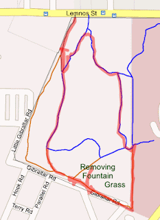
Continuing with fountain grass removal

John and I spent most of today removing the fountain grass we discovered along the southern boundary with the defence department - will need to contact the defence department to get them to remove the fountain grass in their land.
John took a photo of me pushing the wheelbarrow with the results of our labours back to the front gate.

View live map
Click here to download the GPX data for this map. Note, this data is an XML file - change the name to .GPX to upload to your GPS.

Saturday, 14 November 2009

Newsletter #74 November 2009


Thanks to our volunteers
We couldn't deal with all of the weeds that constantly threaten the bushland without the help of volunteers – so thanks to all those who have come along to help this year.

John removing fountain grass flowers

Weed control activities for 2009
We still have a month or so of weeding to do this year, so the maps below may still change before the end of the year.
Freesia – area hand weeded (still to add areas sprayed by City of Nedlands contractors)

View live map
Click here to download the GPX data for this map. Note, this data is an XML file - change the name to .GPX to upload to your GPS.

Flinders ranges wattles removed

View live map
Click here to download the GPX data for this map. Note, this data is an XML file - change the name to .GPX to upload to your GPS.

Geraldton carnation weeds removed (and also marked for future attention)

View live map
Click here to download the GPX data for this map. Note, this data is an XML file - change the name to .GPX to upload to your GPS.

Lachenalia – we only removed isolated plants – will add maps of areas sprayed by City of Nedlands contractors.

View live map
Click here to download the GPX data for this map. Note, this data is an XML file - change the name to .GPX to upload to your GPS.

Miscellaneous weeds – lots of them!

View live map
Click here to download the GPX data for this map. Note, this data is an XML file - change the name to .GPX to upload to your GPS.

Pelargonium are scattered throughout the bushland, and we remove isolated plants as we come across them. This map shows large infestations we dealt with (pelargonium pull) and markers show future areas where we intend to work.

View live map
Click here to download the GPX data for this map. Note, this data is an XML file - change the name to .GPX to upload to your GPS.

We hand removed perennial veldgrass over summer and helped spray in winter. Contractors sprayed the rest of the area this year.

View live map
Click here to download the GPX data for this map. Note, this data is an XML file - change the name to .GPX to upload to your GPS.

Watsonia – hand weeded remnants. Also marked a couple of fresh outbreaks along eastern boundary.

View live map
Click here to download the GPX data for this map. Note, this data is an XML file - change the name to .GPX to upload to your GPS.

AGM
We are planning to hold our AGM early next year – probably a picnic at Matilda Bay – any suggestions for where to hold our meeting are welcome!

Wednesday, 11 November 2009

Getting back to the summer pattern

After the frenetic winter weeding period we are now settling back into a more relaxed summer weeding pattern, cruising around the bushland looking for the odd plant we missed during winter. On Sunday we explored the southern area of the bushland near the Karrakatta Army Barracks, and area that has been quite weedy in the past. We found the usual assortment of ti trees and fountain grass, and also removed a patch of Watsonia that we had discovered earlier in the year.

This is a plant that I was not familiar with - Stenanthum notiale (sub sp chamelum) a small shrub that at first we thought might have been an olive tree!


View live map
Click here to download the GPX data for this map. Note, this data is an XML file - change the name to .GPX to upload to your GPS.

Monday, 26 October 2009

Potential pelargonium pull

John and I were pulling Geraldton Carnation Weeds near Selby Lodge and came across this big patch of pelargonium that would be ideal for a 'pelargonium pull' day.

We also came across this spot where school kids have been doing drugs etc. Loads of rubbish everywhere. Evan a couple of chairs.

We also pulled GCW near the POW camp site. The blue lechanaultia are at their peak at present.

View live map
Click here to download the GPX data for this map. Note, this data is an XML file - change the name to .GPX to upload to your GPS.

Saturday, 26 September 2009

Time for a walk

I took June for a stroll through the bushland this afternoon - the bushland flowers are at their peak - there were so many flowers to look at it took hours for us to get around the 1.5km route.
The local everlastings (Podolepis gracilis) are particularly abundant this year, and visible almost everywhere in the bushland.


The scented sun orchid (Thalymitra macrophylla) has eventually emerged after weeks of cloudy weather.


Swan River Myrtle (Hypocalymma robustum) is a delight to the eye.

Sunday, 20 September 2009

Prickly customers

Years ago we removed a prickly pear from the eastern boundary of the bushland - looked like it had been dumped. We haven't seen a prickly pear since ... then, today we came across two of them!

Vicki joined us today - told us about some potential problems - vetch growing near the noticeboard, fox holes to deal with, and a few bulb species.

The spring showers have been great for orchids this year. This is one of the spider orchids currently out - looks like a 'Rusty Spider Orchid' Caladenia sp..

View live map
Click here to download the GPX data for this map. Note, this data is an XML file - change the name to .GPX to upload to your GPS.

Tuesday, 15 September 2009

Peak flower period

Last weekend was just fabulous in the bushland - it is at its peak in spring flowers. Came across a new one to me - Pimelea sulphurea (yellow banjine) - which isn't in flower yet - so something to watch out for. John and I continued pulling out freesias.
Blue lechanaultia

Fringe lily

Bristly conostylis

Pimelea sulphurea

Morning iris

Cats paw

View live map
Click here to download the GPX data for this map. Note, this data is an XML file - change the name to .GPX to upload to your GPS.

Sunday, 13 September 2009

Aboriginal sites in Perth's Western Suburbs

We occasionally need information about Aboriginal Heritage sites when going for grants, so I have put the data from the Dept of Indigenous Affairs website here. Note, this is current for 2008, and is likely to change over time. Definitive data can be found at the Inquiry System site.
View live map
Click here to download the GPX data for this map. Note, this data is an XML file - change the name to .GPX to upload to your GPS.

Saturday, 12 September 2009

Fire history of Shenton Bushland


This is map of the area burnt by the fire of October 1997

This is a map of areas burnt by fires between 1997 and 2009.
View live map
Click here to download the GPX data for this map. Note, this data is an XML file - change the name to .GPX to upload to your GPS.

A pink fairy emerges

I found this pink fairy orchid at the spot where I was puzzling over some emerging orchids a couple of weeks ago - so now I know what the pink fairy's look like when the emerge.


Came across this callitris while working on a patch of freesias. It is an obvious invader from the army land just 100 m to the west - and there are quite a few callitris planted there.

View live map
Click here to download the GPX data for this map. Note, this data is an XML file - change the name to .GPX to upload to your GPS.